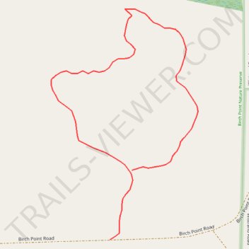
Birch Point Nature Preserve North Loop
- Distance: 0.4 mi
- Elevation gain: 7 ft
- Maximum elevation: 587 ft
- Elevation loss: 7 ft
- Minimum elevation: 577 ft
- Moving time: 12 m 53 s
- Moving speed: 1.8 mph
- Maximum speed: 4.7 mph
- Total time: 12 m 53 s
- Global speed: 1.8 mph
Interactive trail map
Trail profile
- Distance: 0.4 mi
- Elevation gain: 7 ft
- Maximum elevation: 587 ft
- Elevation loss: 7 ft
- Minimum elevation: 577 ft
- Moving time: 12 m 53 s
- Moving speed: 1.8 mph
- Maximum speed: 4.7 mph
- Total time: 12 m 53 s
- Global speed: 1.8 mph
About this trail
Name: Birch Point Nature Preserve North Loop trail, distance, elevation, map, profile, GPS track
Start: Birch Point Road, Lake Township, Benzie County, Michigan, United States (44.69311 -86.13085)
End: Birch Point Road, Lake Township, Benzie County, Michigan, United States (44.69374 -86.13057)
Coordinates: 44.69311 -86.13160 44.69520 -86.12973
Topography: Benzie County topographic map, elevation, terrain