Thank you for supporting this site ❤️
Make a donation
Make a donation
Gear up for your next adventure:
As an Amazon Associate, this site earns from qualifying purchases at no extra cost to you.
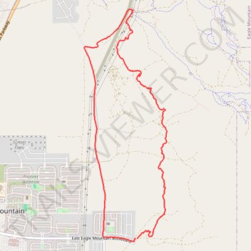
AC/DC New Trails To Explore
- Distance: 6.4 mi
- Elevation gain: 548 ft
- Maximum elevation: 5,279 ft
- Elevation loss: 551 ft
- Minimum elevation: 4,905 ft
- Moving time: 58 m 43 s
- Moving speed: 6.5 mph
- Maximum speed: 23.9 mph
- Total time: 1 h 8 m
- Global speed: 5.6 mph
Interactive trail map
Thank you for supporting this site ❤️
Make a donation
Make a donation
Gear up for your next adventure:
As an Amazon Associate, this site earns from qualifying purchases at no extra cost to you.
Trail profile
- Distance: 6.4 mi
- Elevation gain: 548 ft
- Maximum elevation: 5,279 ft
- Elevation loss: 551 ft
- Minimum elevation: 4,905 ft
- Moving time: 58 m 43 s
- Moving speed: 6.5 mph
- Maximum speed: 23.9 mph
- Total time: 1 h 8 m
- Global speed: 5.6 mph
Thank you for supporting this site ❤️
Make a donation
Make a donation
Gear up for your next adventure:
As an Amazon Associate, this site earns from qualifying purchases at no extra cost to you.
About this trail
Name: AC/DC New Trails To Explore trail, distance, elevation, map, profile, GPS track
Coordinates: 40.30489 -111.99595 40.33827 -111.98037
Topography: Utah County topographic map, elevation, terrain
Thank you for supporting this site ❤️
Make a donation
Make a donation
Gear up for your next adventure:
As an Amazon Associate, this site earns from qualifying purchases at no extra cost to you.