Long Point Viewpoint
Hike to Long Point Viewpoint via Long Point Trail in New River Gorge National Park and Preserve #Hiking #Forest #Gorge
- Distance: 3.1 mi
- Elevation gain: 469 ft
- Maximum elevation: 1,946 ft
- Elevation loss: 472 ft
- Minimum elevation: 1,549 ft
- Moving time: 1 h 19 m
- Moving speed: 2.3 mph
- Maximum speed: 3.9 mph
- Total time: 1 h 24 m
- Global speed: 2.2 mph
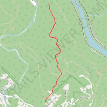
Interactive trail map
Trail profile
- Distance: 3.1 mi
- Elevation gain: 469 ft
- Maximum elevation: 1,946 ft
- Elevation loss: 472 ft
- Minimum elevation: 1,549 ft
- Moving time: 1 h 19 m
- Moving speed: 2.3 mph
- Maximum speed: 3.9 mph
- Total time: 1 h 24 m
- Global speed: 2.2 mph
About this trail
Name: Long Point Viewpoint trail, distance, elevation, map, profile, GPS track
Start: Long Point Trail, Fayette County, West Virginia, 25840, United States (38.04169 -81.07799)
End: Long Point Trail, Fayette County, West Virginia, 25840, United States (38.04173 -81.07805)
Coordinates: 38.04169 -81.07813 38.05968 -81.07448
Topography: Fayette County topographic map, elevation, terrain
Other hiking, mountain biking, running and outdoor activity trails
Click on a trail to view its statistics, map and profile.
New River Gorge
United States > West Virginia > Mercer County > Athens
Distance: 128.2 mi • Elevation gain: 17,510 ft • Maximum elevation: 2,792 ft
Long Point Trail in New River Gorge National Park and Preserve
United States > West Virginia > Fayette County
The Long Point Trail offers a delightful escape into nature, where every step brings you closer to breathtaking vistas of the expansive gorge below. As you traverse the well-maintained path, you’ll be greeted by the whispering winds through the trees and stunning views of the iconic New River Gorge Bridge,…
Distance: 3.1 mi • Elevation gain: 469 ft • Maximum elevation: 1,946 ft
Long Point Trail to Viewpoint in New River Gorge National Park and Preserve
United States > West Virginia > Fayette County
The Long Point Trail in New River Gorge National Park and Preserve offers hikers a scenic journey through lush forests, culminating in a breathtaking overlook of the New River Gorge Bridge. Along the way, the trail meanders through diverse woodlands, providing glimpses of local flora and fauna. The final…
Distance: 3.1 mi • Elevation gain: 476 ft • Maximum elevation: 1,942 ft