Make a donation
Gear up for your next adventure:
As an Amazon Associate, this site earns from qualifying purchases at no extra cost to you.
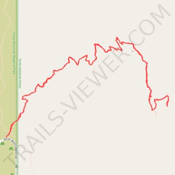
Wind Cave Trail in Tonto National Forest
The Wind Cave Trail in Arizona's Tonto National Forest offers hikers a rewarding journey through Sonoran Desert landscape. Along the path, you'll encounter rugged terrain, including steep ascents and rocky sections, leading to the distinctive Wind Cave—a natural alcove carved into the mountainside. From the trail's summit, panoramic views of the surrounding desert vistas, mountain ranges, and the distant cityscape of Phoenix unfold, providing a memorable hiking experience. #Hiking #Mountain #Desert #Nature #Overlook
- Distance: 3.3 mi
- Elevation gain: 1,135 ft
- Maximum elevation: 3,054 ft
- Elevation loss: 1,129 ft
- Minimum elevation: 2,024 ft
- Moving time: 1 h 34 m
- Moving speed: 2.1 mph
- Maximum speed: 4.1 mph
- Total time: 1 h 48 m
- Global speed: 1.8 mph
Interactive trail map
Make a donation
Gear up for your next adventure:
As an Amazon Associate, this site earns from qualifying purchases at no extra cost to you.
Trail profile
- Distance: 3.3 mi
- Elevation gain: 1,135 ft
- Maximum elevation: 3,054 ft
- Elevation loss: 1,129 ft
- Minimum elevation: 2,024 ft
- Moving time: 1 h 34 m
- Moving speed: 2.1 mph
- Maximum speed: 4.1 mph
- Total time: 1 h 48 m
- Global speed: 1.8 mph
Make a donation
Gear up for your next adventure:
As an Amazon Associate, this site earns from qualifying purchases at no extra cost to you.
About this trail
Name: Wind Cave Trail in Tonto National Forest trail, distance, elevation, map, profile, GPS track
Start: North Wind Cave Drive, Maricopa County, Arizona, 85207, United States (33.47401 -111.60738)
End: Wind Cave Trail, Maricopa County, Arizona, 85207, United States (33.47413 -111.60725)
Coordinates: 33.47401 -111.60738 33.48009 -111.59563
Topography: Maricopa County topographic map, elevation, terrain
Make a donation
Gear up for your next adventure:
As an Amazon Associate, this site earns from qualifying purchases at no extra cost to you.
Other hiking, mountain biking, running and outdoor activity trails
Click on a trail to view its statistics, map and profile.