Make a donation
Gear up for your next adventure:
As an Amazon Associate, this site earns from qualifying purchases at no extra cost to you.
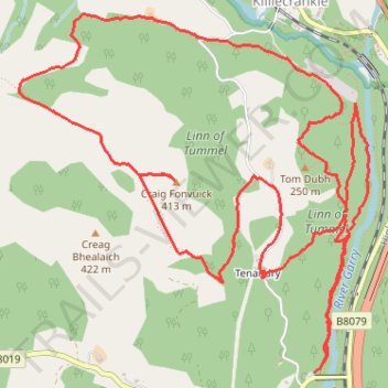
Loop run at Craig Fonvuick
- Distance: 6.4 mi
- Elevation gain: 1,483 ft
- Maximum elevation: 1,325 ft
- Elevation loss: 1,506 ft
- Minimum elevation: 371 ft
- Moving time: 1 h 59 m
- Moving speed: 3.2 mph
- Maximum speed: 17.9 mph
- Total time: 2 h 20 m
- Global speed: 2.7 mph
Interactive trail map
Make a donation
Gear up for your next adventure:
As an Amazon Associate, this site earns from qualifying purchases at no extra cost to you.
Trail profile
- Distance: 6.4 mi
- Elevation gain: 1,483 ft
- Maximum elevation: 1,325 ft
- Elevation loss: 1,506 ft
- Minimum elevation: 371 ft
- Moving time: 1 h 59 m
- Moving speed: 3.2 mph
- Maximum speed: 17.9 mph
- Total time: 2 h 20 m
- Global speed: 2.7 mph
Make a donation
Gear up for your next adventure:
As an Amazon Associate, this site earns from qualifying purchases at no extra cost to you.
About this trail
Name: Loop run at Craig Fonvuick trail, distance, elevation, map, profile, GPS track
Start: B8019, Tenandry, Perth and Kinross, Scotland, PH16 5LE, United Kingdom (56.72806 -3.77724)
Coordinates: 56.72806 -3.80178 56.74434 -3.77273
Make a donation
Gear up for your next adventure:
As an Amazon Associate, this site earns from qualifying purchases at no extra cost to you.
Other hiking, mountain biking, running and outdoor activity trails
Click on a trail to view its statistics, map and profile.
Loch Tummel Loop
United Kingdom > Scotland > Perth and Kinross > Pitlochry
To Escape Route Cafe UK, Perthshire, Loch Tummel
Distance: 28.7 mi • Elevation gain: 2,687 ft • Maximum elevation: 948 ft