Make a donation
Gear up for your next adventure:
As an Amazon Associate, this site earns from qualifying purchases at no extra cost to you.
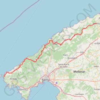
GR221 tramuntana
- Distance: 72.1 mi
- Elevation gain: 19,196 ft
- Maximum elevation: 3,967 ft
- Elevation loss: 19,367 ft
- Minimum elevation: 20 ft
Interactive trail map
Make a donation
Gear up for your next adventure:
As an Amazon Associate, this site earns from qualifying purchases at no extra cost to you.
Trail profile
- Distance: 72.1 mi
- Elevation gain: 19,196 ft
- Maximum elevation: 3,967 ft
- Elevation loss: 19,367 ft
- Minimum elevation: 20 ft
Make a donation
Gear up for your next adventure:
As an Amazon Associate, this site earns from qualifying purchases at no extra cost to you.
About this trail
Name: GR221 tramuntana trail, distance, elevation, map, profile, GPS track
Coordinates: 39.58387 2.35049 39.88209 3.01261
Make a donation
Gear up for your next adventure:
As an Amazon Associate, this site earns from qualifying purchases at no extra cost to you.
Other hiking, mountain biking, running and outdoor activity trails
Click on a trail to view its statistics, map and profile.
GR221 tramuntana
Spain > Balearic Islands > Serra de Tramuntana > Pollença
Distance: 72.1 mi • Elevation gain: 19,196 ft • Maximum elevation: 3,967 ft
Southern section — European Divide Trail
France > Auvergne-Rhône-Alpes > Drôme > Valence
Distance: 1,506.1 mi • Elevation gain: 139,026 ft • Maximum elevation: 6,578 ft
1 LUCENA - MONTPELLIER
Distance: 1,842.0 mi • Elevation gain: 96,785 ft • Maximum elevation: 3,438 ft
Lluc Puig d'en Galileu et Puig Massanella
Spain > Balearic Islands > Serra de Tramuntana > Escorca > Lluc
https://en-hk.gps-viewer.com/track-lwq4s/Lluc-Puig-d-en-Galileu-et-Puig-Massanella/
Distance: 10.7 mi • Elevation gain: 3,514 ft • Maximum elevation: 4,403 ft
Make a donation
Gear up for your next adventure:
As an Amazon Associate, this site earns from qualifying purchases at no extra cost to you.