Thank you for supporting this site ❤️
Make a donation
Make a donation
Gear up for your next adventure:
As an Amazon Associate, this site earns from qualifying purchases at no extra cost to you.
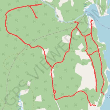
Lake Tormont Hiking
- Distance: 9.9 mi
- Elevation gain: 512 ft
- Maximum elevation: 741 ft
- Elevation loss: 535 ft
- Minimum elevation: 574 ft
- Moving time: 1 h 25 s
- Moving speed: 9.8 mph
- Maximum speed: 41.3 mph
- Total time: 1 h 3 m
- Global speed: 9.4 mph
Interactive trail map
Thank you for supporting this site ❤️
Make a donation
Make a donation
Gear up for your next adventure:
As an Amazon Associate, this site earns from qualifying purchases at no extra cost to you.
Trail profile
- Distance: 9.9 mi
- Elevation gain: 512 ft
- Maximum elevation: 741 ft
- Elevation loss: 535 ft
- Minimum elevation: 574 ft
- Moving time: 1 h 25 s
- Moving speed: 9.8 mph
- Maximum speed: 41.3 mph
- Total time: 1 h 3 m
- Global speed: 9.4 mph
Thank you for supporting this site ❤️
Make a donation
Make a donation
Gear up for your next adventure:
As an Amazon Associate, this site earns from qualifying purchases at no extra cost to you.
About this trail
Name: Lake Tormont Hiking trail, distance, elevation, map, profile, GPS track
Coordinates: 44.73162 -64.77162 44.75259 -64.74292
Thank you for supporting this site ❤️
Make a donation
Make a donation
Gear up for your next adventure:
As an Amazon Associate, this site earns from qualifying purchases at no extra cost to you.
Other hiking, mountain biking, running and outdoor activity trails
Click on a trail to view its statistics, map and profile.
Lake Tormont Trails
Canada > Nova Scotia > Municipality of the County of Kings > East Dalhousie
Distance: 6.4 mi • Elevation gain: 315 ft • Maximum elevation: 738 ft