Make a donation
Gear up for your next adventure:
As an Amazon Associate, this site earns from qualifying purchases at no extra cost to you.
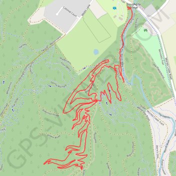
Mountain Bike Ride in Porepunkah Plantation
Interactive trail map
Make a donation
Gear up for your next adventure:
As an Amazon Associate, this site earns from qualifying purchases at no extra cost to you.
Trail profile
- Distance: 4.5 mi
- Elevation gain: 1,073 ft
- Maximum elevation: 1,804 ft
- Elevation loss: 1,010 ft
- Minimum elevation: 1,063 ft
- Moving time: 45 m 2 s
- Moving speed: 6.0 mph
- Maximum speed: 7.4 mph
- Total time: 45 m 2 s
- Global speed: 6.0 mph
Make a donation
Gear up for your next adventure:
As an Amazon Associate, this site earns from qualifying purchases at no extra cost to you.
About this trail
Name: Mountain Bike Ride in Porepunkah Plantation trail, distance, elevation, map, profile, GPS track
Start: Short And Sweet, Bright, Alpine Shire, Victoria, 3741, Australia (-36.74270 146.97664)
Coordinates: -36.75288 146.96975 -36.74263 146.97670
Make a donation
Gear up for your next adventure:
As an Amazon Associate, this site earns from qualifying purchases at no extra cost to you.
Other hiking, mountain biking, running and outdoor activity trails
Click on a trail to view its statistics, map and profile.
Mount Beauty - Pyramid Hill - Bright
Australia > Victoria > Mount Beauty
#MTB
Distance: 29.7 mi • Elevation gain: 5,623 ft • Maximum elevation: 4,505 ft
Bright Moutain Bike Park
Porepunkah Plantation. #MTB #Loop #Porepunkah
Distance: 13.3 mi • Elevation gain: 1,483 ft • Maximum elevation: 1,696 ft
Make a donation
Gear up for your next adventure:
As an Amazon Associate, this site earns from qualifying purchases at no extra cost to you.