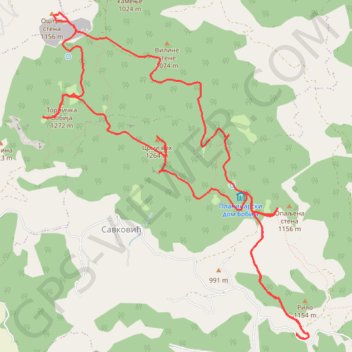
BOBIJA: Opaljena Stena (1.156) - Oštra Stena (1.158) - Crni ...
- Distance: 9.0 mi
- Elevation gain: 1,936 ft
- Maximum elevation: 4,124 ft
- Elevation loss: 1,936 ft
- Minimum elevation: 3,215 ft
- Moving time: 7 h 31 m
- Moving speed: 1.2 mph
- Maximum speed: 3.9 mph
- Total time: 10 h 49 m
- Global speed: 0.8 mph
Interactive trail map
Trail profile
- Distance: 9.0 mi
- Elevation gain: 1,936 ft
- Maximum elevation: 4,124 ft
- Elevation loss: 1,936 ft
- Minimum elevation: 3,215 ft
- Moving time: 7 h 31 m
- Moving speed: 1.2 mph
- Maximum speed: 3.9 mph
- Total time: 10 h 49 m
- Global speed: 0.8 mph
About this trail
Name: BOBIJA: Opaljena Stena (1.156) - Oštra Stena (1.158) - Crni ... trail, distance, elevation, map, profile, GPS track
Coordinates: 44.17461 19.55200 44.20525 19.58696
Other hiking, mountain biking, running and outdoor activity trails
Click on a trail to view its statistics, map and profile.
2022_Yu
Slovenia > Ajdovščina > Žapuže
Distance: 1,526.9 mi • Elevation gain: 105,144 ft • Maximum elevation: 6,398 ft