Import a GPX file

Tristania Falls - Crystal Shower Falls - Wonga Walk

Dorrigo National Park. #Hiking #Loop #Dorrigo

  • Distance: 4.3 mi
  • Elevation gain: 1,135 ft
  • Maximum elevation: 2,530 ft
  • Elevation loss: 1,119 ft
  • Minimum elevation: 1,975 ft
  • Moving time: 1 h 29 m
  • Moving speed: 2.9 mph
  • Maximum speed: 8.0 mph
  • Total time: 1 h 31 m
  • Global speed: 2.8 mph

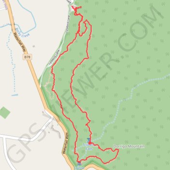
Interactive trail map

Trail profile

  • Distance: 4.3 mi
  • Elevation gain: 1,135 ft
  • Maximum elevation: 2,530 ft
  • Elevation loss: 1,119 ft
  • Minimum elevation: 1,975 ft
  • Moving time: 1 h 29 m
  • Moving speed: 2.9 mph
  • Maximum speed: 8.0 mph
  • Total time: 1 h 31 m
  • Global speed: 2.8 mph

About this trail

Name: Tristania Falls - Crystal Shower Falls - Wonga Walk trail, distance, elevation, map, profile, GPS track

Start: Lyrebird Link, Dorrigo Mountain, Bellingen Shire Council, New South Wales, 2453, Australia (-30.36397 152.72896)

End: Lyrebird Lane, Dorrigo Mountain, Bellingen Shire Council, New South Wales, 2453, Australia (-30.36351 152.72858)

Coordinates: -30.38080 152.72600 -30.36351 152.73453

Other hiking, mountain biking, running and outdoor activity trails

Click on a trail to view its statistics, map and profile.

Tristania Falls - Crystal Shower Falls - Hardwood Lookout - Wonga Walk

Australia > New South Wales > Dorrigo Mountain

Dorrigo National Park. #Hiking #Loop #Dorrigo

Distance: 4.4 mi • Elevation gain: 1,119 ft • Maximum elevation: 2,526 ft

Gear up for your next adventure:

🔥Plasma Lighters - Windproof lighters that work in any weather condition
🕶️GPS Smartphone Mount - Secure mount for phone navigation
🛶Inflatable Kayak - Portable kayak for rivers, lakes, and expeditions
📶Satellite Messenger - Communication device off‑grid
🛏️Cold Weather Sleeping Bag - Warm sleeping bag for cold conditions

As an Amazon Associate, this site earns from qualifying purchases at no extra cost to you.