Make a donation
Gear up for your next adventure:
As an Amazon Associate, this site earns from qualifying purchases at no extra cost to you.
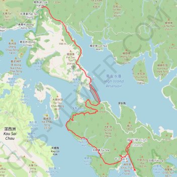
深篤南坑 深篤南右坑 北丫左坑 糧船灣大坑
Outdoor hiking
- Distance: 8.0 mi
- Elevation gain: 1,522 ft
- Maximum elevation: 305 ft
- Elevation loss: 1,532 ft
- Minimum elevation: -7 ft
- Moving time: 3 h 17 m
- Moving speed: 2.4 mph
- Maximum speed: 5.7 mph
- Total time: 5 h 34 m
- Global speed: 1.4 mph
Interactive trail map
Make a donation
Gear up for your next adventure:
As an Amazon Associate, this site earns from qualifying purchases at no extra cost to you.
Trail profile
- Distance: 8.0 mi
- Elevation gain: 1,522 ft
- Maximum elevation: 305 ft
- Elevation loss: 1,532 ft
- Minimum elevation: -7 ft
- Moving time: 3 h 17 m
- Moving speed: 2.4 mph
- Maximum speed: 5.7 mph
- Total time: 5 h 34 m
- Global speed: 1.4 mph
Make a donation
Gear up for your next adventure:
As an Amazon Associate, this site earns from qualifying purchases at no extra cost to you.
About this trail
Name: 深篤南坑 深篤南右坑 北丫左坑 糧船灣大坑 trail, distance, elevation, map, profile, GPS track
Coordinates: 22.35018 114.32305 22.39998 114.35400
Make a donation
Gear up for your next adventure:
As an Amazon Associate, this site earns from qualifying purchases at no extra cost to you.
Other hiking, mountain biking, running and outdoor activity trails
Click on a trail to view its statistics, map and profile.
城門~北潭坳
China > Hong Kong > Tsuen Wan District > Kwai Chung > Lower Shing Mun Village
ShingMunReservoir~PakTamAu
Distance: 23.3 mi • Elevation gain: 7,156 ft • Maximum elevation: 1,808 ft
田尾下源 橫頭墩北坑 田鹿石澗左 蛇地 秋楓
China > Hong Kong > Sai Kung District > Tsak Yue Wu
Distance: 13.1 mi • Elevation gain: 2,661 ft • Maximum elevation: 1,102 ft
大往灣坑 泥鯭埔坑
China > Hong Kong > Sai Kung District > Yim Tin Tsai
Hong Kong Hike
Distance: 5.4 mi • Elevation gain: 1,234 ft • Maximum elevation: 482 ft
鯽魚湖南坑 雷花石澗 坪輋西坑
China > Hong Kong > Sai Kung District
Hong Kong Hike
Distance: 6.9 mi • Elevation gain: 2,316 ft • Maximum elevation: 1,201 ft
Make a donation
Gear up for your next adventure:
As an Amazon Associate, this site earns from qualifying purchases at no extra cost to you.
麦理浩径
China > Hong Kong > Sai Kung District > Tsak Yue Wu
北潭涌至屯门
Distance: 61.3 mi • Elevation gain: 16,886 ft • Maximum elevation: 3,031 ft