Thank you for supporting this site ❤️
Make a donation
Make a donation
Gear up for your next adventure:
As an Amazon Associate, this site earns from qualifying purchases at no extra cost to you.
Tea Kettle Trail
- Distance: 5.7 mi
- Elevation gain: 732 ft
- Maximum elevation: 1,453 ft
- Elevation loss: 732 ft
- Minimum elevation: 1,234 ft
- Moving time: 2 h 5 m
- Moving speed: 2.7 mph
- Maximum speed: 7.2 mph
- Total time: 2 h 46 m
- Global speed: 2.1 mph
Interactive trail map
Thank you for supporting this site ❤️
Make a donation
Make a donation
Gear up for your next adventure:
As an Amazon Associate, this site earns from qualifying purchases at no extra cost to you.
Trail profile
- Distance: 5.7 mi
- Elevation gain: 732 ft
- Maximum elevation: 1,453 ft
- Elevation loss: 732 ft
- Minimum elevation: 1,234 ft
- Moving time: 2 h 5 m
- Moving speed: 2.7 mph
- Maximum speed: 7.2 mph
- Total time: 2 h 46 m
- Global speed: 2.1 mph
Thank you for supporting this site ❤️
Make a donation
Make a donation
Gear up for your next adventure:
As an Amazon Associate, this site earns from qualifying purchases at no extra cost to you.
About this trail
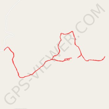
Name: Tea Kettle Trail trail, distance, elevation, map, profile, GPS track
Start: Madison County, Arkansas, United States (36.26756 -93.73291)
End: Madison County, Arkansas, United States (36.26745 -93.73298)
Coordinates: 36.26220 -93.73298 36.27115 -93.70886
Topography: Madison County topographic map, elevation, terrain
Thank you for supporting this site ❤️
Make a donation
Make a donation
Gear up for your next adventure:
As an Amazon Associate, this site earns from qualifying purchases at no extra cost to you.