Thank you for supporting this site ❤️
Make a donation
Make a donation
Gear up for your next adventure:
As an Amazon Associate, this site earns from qualifying purchases at no extra cost to you.
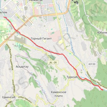
20240406 Outdoor cycling
- Distance: 4.9 mi
- Elevation gain: 1,132 ft
- Maximum elevation: 3,904 ft
- Elevation loss: 69 ft
- Minimum elevation: 2,835 ft
- Moving time: 57 m 32 s
- Moving speed: 5.1 mph
- Maximum speed: 17.5 mph
- Total time: 57 m 32 s
- Global speed: 5.1 mph
Interactive trail map
Thank you for supporting this site ❤️
Make a donation
Make a donation
Gear up for your next adventure:
As an Amazon Associate, this site earns from qualifying purchases at no extra cost to you.
Trail profile
- Distance: 4.9 mi
- Elevation gain: 1,132 ft
- Maximum elevation: 3,904 ft
- Elevation loss: 69 ft
- Minimum elevation: 2,835 ft
- Moving time: 57 m 32 s
- Moving speed: 5.1 mph
- Maximum speed: 17.5 mph
- Total time: 57 m 32 s
- Global speed: 5.1 mph
Thank you for supporting this site ❤️
Make a donation
Make a donation
Gear up for your next adventure:
As an Amazon Associate, this site earns from qualifying purchases at no extra cost to you.
About this trail
Name: 20240406 Outdoor cycling trail, distance, elevation, map, profile, GPS track
End: Терренкур, Medeu District, Almaty, 050020, Kazakhstan (43.18925 76.99377)
Coordinates: 43.18925 76.92318 43.22739 76.99377
Thank you for supporting this site ❤️
Make a donation
Make a donation
Gear up for your next adventure:
As an Amazon Associate, this site earns from qualifying purchases at no extra cost to you.