Thank you for supporting this site ❤️
Make a donation
Make a donation
Gear up for your next adventure:
As an Amazon Associate, this site earns from qualifying purchases at no extra cost to you.
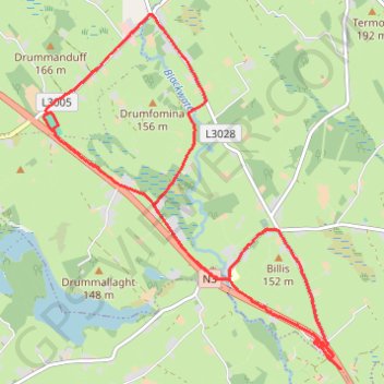
Killinkere
Lunch Run
- Distance: 7.9 mi
- Elevation gain: 446 ft
- Maximum elevation: 479 ft
- Elevation loss: 463 ft
- Minimum elevation: 325 ft
- Moving time: 1 h 6 m
- Moving speed: 7.1 mph
- Maximum speed: 14.3 mph
- Total time: 1 h 6 m
- Global speed: 7.1 mph
Interactive trail map
Thank you for supporting this site ❤️
Make a donation
Make a donation
Gear up for your next adventure:
As an Amazon Associate, this site earns from qualifying purchases at no extra cost to you.
Trail profile
- Distance: 7.9 mi
- Elevation gain: 446 ft
- Maximum elevation: 479 ft
- Elevation loss: 463 ft
- Minimum elevation: 325 ft
- Moving time: 1 h 6 m
- Moving speed: 7.1 mph
- Maximum speed: 14.3 mph
- Total time: 1 h 6 m
- Global speed: 7.1 mph
Thank you for supporting this site ❤️
Make a donation
Make a donation
Gear up for your next adventure:
As an Amazon Associate, this site earns from qualifying purchases at no extra cost to you.
About this trail
Name: Killinkere trail, distance, elevation, map, profile, GPS track
Coordinates: 53.87827 -7.17576 53.91166 -7.12834
Thank you for supporting this site ❤️
Make a donation
Make a donation
Gear up for your next adventure:
As an Amazon Associate, this site earns from qualifying purchases at no extra cost to you.