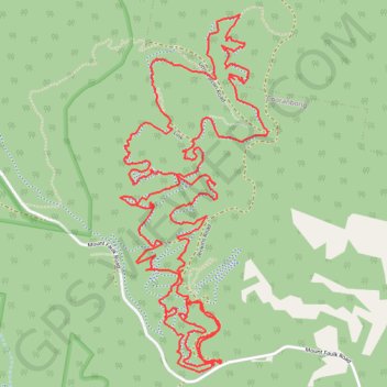
Import a GPX file

Awaba Red Loop

#MTB #Loop #Awaba

  • Distance: 7.8 mi
  • Elevation gain: 1,424 ft
  • Maximum elevation: 453 ft
  • Elevation loss: 1,424 ft
  • Minimum elevation: 187 ft

Interactive trail map

Trail profile

  • Distance: 7.8 mi
  • Elevation gain: 1,424 ft
  • Maximum elevation: 453 ft
  • Elevation loss: 1,424 ft
  • Minimum elevation: 187 ft

About this trail

Gear up for your next adventure:

🪶Wildlife Field Guides - Learn animal tracking and species ID
🪶Survival Guide Book - Expert advice for emergency preparedness
🦶Hiking Gaiters - Keep debris and water out of your boots
🛌Ultralight Sleeping Bags - Compact down bags for cold nights in the wilderness
📚Navigation Handbooks - Master the art of reading topographic maps and using a compass

As an Amazon Associate, this site earns from qualifying purchases at no extra cost to you.