Fall Line Trail Cycling, Ashland to Henrico
- Distance: 6.9 mi
- Elevation gain: 118 ft
- Maximum elevation: 230 ft
- Elevation loss: 184 ft
- Minimum elevation: 154 ft
- Moving time: 57 m 49 s
- Moving speed: 7.1 mph
- Maximum speed: 14.8 mph
- Total time: 1 h 27 s
- Global speed: 6.8 mph
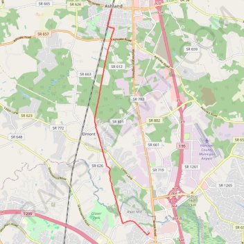
Interactive trail map
Trail profile
- Distance: 6.9 mi
- Elevation gain: 118 ft
- Maximum elevation: 230 ft
- Elevation loss: 184 ft
- Minimum elevation: 154 ft
- Moving time: 57 m 49 s
- Moving speed: 7.1 mph
- Maximum speed: 14.8 mph
- Total time: 1 h 27 s
- Global speed: 6.8 mph
About this trail
Name: Fall Line Trail Cycling, Ashland to Henrico trail, distance, elevation, map, profile, GPS track
Start: South Railroad Avenue, Ashland, Hanover County, Virginia, 23005, United States (37.75814 -77.48166)
Coordinates: 37.67315 -77.48962 37.75814 -77.46356
Topography: Hanover County topographic map, elevation, terrain