Make a donation
Gear up for your next adventure:
As an Amazon Associate, this site earns from qualifying purchases at no extra cost to you.
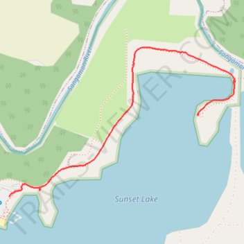
Riverbend Forest Preserve - Sunset Lake
- Distance: 0.8 mi
- Elevation gain: 20 ft
- Maximum elevation: 692 ft
- Elevation loss: 26 ft
- Minimum elevation: 673 ft
- Moving time: 24 m 38 s
- Moving speed: 2.0 mph
- Maximum speed: 3.0 mph
- Total time: 28 m 37 s
- Global speed: 1.8 mph
Interactive trail map
Make a donation
Gear up for your next adventure:
As an Amazon Associate, this site earns from qualifying purchases at no extra cost to you.
Trail profile
- Distance: 0.8 mi
- Elevation gain: 20 ft
- Maximum elevation: 692 ft
- Elevation loss: 26 ft
- Minimum elevation: 673 ft
- Moving time: 24 m 38 s
- Moving speed: 2.0 mph
- Maximum speed: 3.0 mph
- Total time: 28 m 37 s
- Global speed: 1.8 mph
Make a donation
Gear up for your next adventure:
As an Amazon Associate, this site earns from qualifying purchases at no extra cost to you.
About this trail
Name: Riverbend Forest Preserve - Sunset Lake trail, distance, elevation, map, profile, GPS track
Start: South Clapper Drive, Mahomet, Champaign County, Illinois, 61853, United States (40.18225 -88.42784)
End: Beaver Lake Court, Mahomet, Champaign County, Illinois, 61853, United States (40.18464 -88.42054)
Coordinates: 40.18225 -88.42784 40.18665 -88.41910
Topography: Champaign County topographic map, elevation, terrain
Make a donation
Gear up for your next adventure:
As an Amazon Associate, this site earns from qualifying purchases at no extra cost to you.