Thank you for supporting this site ❤️
Make a donation
Make a donation
Gear up for your next adventure:
As an Amazon Associate, this site earns from qualifying purchases at no extra cost to you.
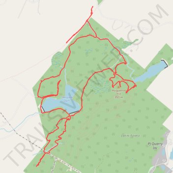
Port Jervis Watershed and Recreation Area
- Distance: 12.3 mi
- Elevation gain: 909 ft
- Maximum elevation: 1,230 ft
- Elevation loss: 909 ft
- Minimum elevation: 925 ft
- Moving time: 4 h 2 m
- Moving speed: 3.0 mph
- Maximum speed: 23.3 mph
- Total time: 7 h 20 m
- Global speed: 1.7 mph
Interactive trail map
Thank you for supporting this site ❤️
Make a donation
Make a donation
Gear up for your next adventure:
As an Amazon Associate, this site earns from qualifying purchases at no extra cost to you.
Trail profile
- Distance: 12.3 mi
- Elevation gain: 909 ft
- Maximum elevation: 1,230 ft
- Elevation loss: 909 ft
- Minimum elevation: 925 ft
- Moving time: 4 h 2 m
- Moving speed: 3.0 mph
- Maximum speed: 23.3 mph
- Total time: 7 h 20 m
- Global speed: 1.7 mph
Thank you for supporting this site ❤️
Make a donation
Make a donation
Gear up for your next adventure:
As an Amazon Associate, this site earns from qualifying purchases at no extra cost to you.
About this trail
Name: Port Jervis Watershed and Recreation Area trail, distance, elevation, map, profile, GPS track
Coordinates: 41.39786 -74.69876 41.43311 -74.66945
Topography: Orange County topographic map, elevation, terrain
Thank you for supporting this site ❤️
Make a donation
Make a donation
Gear up for your next adventure:
As an Amazon Associate, this site earns from qualifying purchases at no extra cost to you.
Other hiking, mountain biking, running and outdoor activity trails
Click on a trail to view its statistics, map and profile.
Port Jervis Watershed
United States > New York > Orange County
Distance: 29.3 mi • Elevation gain: 3,015 ft • Maximum elevation: 1,125 ft