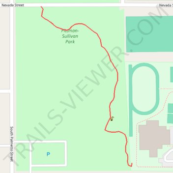
Pittman-Sullivan Park
- Distance: 0.3 mi
- Elevation gain: 13 ft
- Maximum elevation: 732 ft
- Elevation loss: 16 ft
- Minimum elevation: 715 ft
- Moving time: 5 m 10 s
- Moving speed: 2.9 mph
- Maximum speed: 5.1 mph
- Total time: 6 m 3 s
- Global speed: 2.5 mph
Interactive trail map
Trail profile
- Distance: 0.3 mi
- Elevation gain: 13 ft
- Maximum elevation: 732 ft
- Elevation loss: 16 ft
- Minimum elevation: 715 ft
- Moving time: 5 m 10 s
- Moving speed: 2.9 mph
- Maximum speed: 5.1 mph
- Total time: 6 m 3 s
- Global speed: 2.5 mph
About this trail
Name: Pittman-Sullivan Park trail, distance, elevation, map, profile, GPS track
Coordinates: 29.41217 -98.46487 29.41459 -98.46329
Topography: San Antonio topographic map, elevation, terrain