Brakel
- Distance: 3.6 mi
- Elevation gain: 295 ft
- Maximum elevation: 302 ft
- Elevation loss: 295 ft
- Minimum elevation: 157 ft
Interactive trail map
Trail profile
- Distance: 3.6 mi
- Elevation gain: 295 ft
- Maximum elevation: 302 ft
- Elevation loss: 295 ft
- Minimum elevation: 157 ft
About this trail
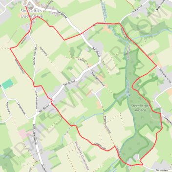
Name: Brakel trail, distance, elevation, map, profile, GPS track
Coordinates: 50.83818 3.78323 50.85288 3.80547
Other hiking, mountain biking, running and outdoor activity trails
Click on a trail to view its statistics, map and profile.
Ronde van Vlaanderen fietsroute gele lus
Belgium > East Flanders > Oudenaarde > Oudenaarde
Distance: 63.4 mi • Elevation gain: 2,900 ft • Maximum elevation: 302 ft
60km
Belgium > East Flanders > Oudenaarde > Zwalm > Sint-Denijs-Boekel
name=60km
Distance: 37.3 mi • Elevation gain: 1,578 ft • Maximum elevation: 335 ft
GR-122 - 25Km
Belgium > East Flanders > Oudenaarde > Zwalm > Sint-Denijs-Boekel
name=GR-122 - 25Km
Distance: 15.7 mi • Elevation gain: 981 ft • Maximum elevation: 299 ft
Iedereen 1000 KOTK OVL noordlus 131km met Iben en Jana (eindresultaat deze wk 469km gefietst, 23K gelopen en 12K gewandeld)
Belgium > East Flanders > Gent > Heusden
Distance: 80.9 mi • Elevation gain: 1,900 ft • Maximum elevation: 266 ft
GRR122 - 30km
Belgium > East Flanders > Oudenaarde > Zwalm > Sint-Denijs-Boekel
name=GRR122 - 30km
Distance: 18.6 mi • Elevation gain: 1,145 ft • Maximum elevation: 299 ft