Thank you for supporting this site ❤️
Make a donation
Make a donation
Gear up for your next adventure:
As an Amazon Associate, this site earns from qualifying purchases at no extra cost to you.
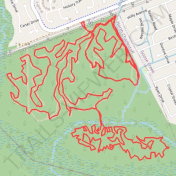
Wannamaker North Ride
- Distance: 13.9 mi
- Elevation gain: 164 ft
- Maximum elevation: 39 ft
- Elevation loss: 164 ft
- Minimum elevation: 7 ft
- Moving time: 1 h 51 m
- Moving speed: 7.5 mph
- Maximum speed: 19.1 mph
- Total time: 1 h 53 m
- Global speed: 7.3 mph
Interactive trail map
Thank you for supporting this site ❤️
Make a donation
Make a donation
Gear up for your next adventure:
As an Amazon Associate, this site earns from qualifying purchases at no extra cost to you.
Trail profile
- Distance: 13.9 mi
- Elevation gain: 164 ft
- Maximum elevation: 39 ft
- Elevation loss: 164 ft
- Minimum elevation: 7 ft
- Moving time: 1 h 51 m
- Moving speed: 7.5 mph
- Maximum speed: 19.1 mph
- Total time: 1 h 53 m
- Global speed: 7.3 mph
Thank you for supporting this site ❤️
Make a donation
Make a donation
Gear up for your next adventure:
As an Amazon Associate, this site earns from qualifying purchases at no extra cost to you.
About this trail
Name: Wannamaker North Ride trail, distance, elevation, map, profile, GPS track
Coordinates: 32.98740 -80.06661 32.99945 -80.05049
Topography: Berkeley County topographic map, elevation, terrain
Thank you for supporting this site ❤️
Make a donation
Make a donation
Gear up for your next adventure:
As an Amazon Associate, this site earns from qualifying purchases at no extra cost to you.