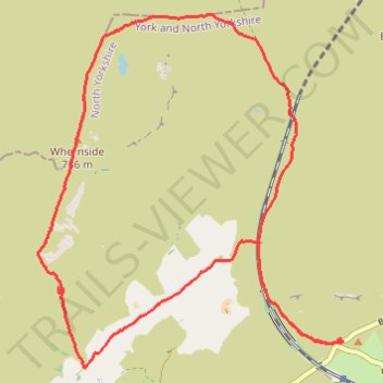
Whernside loop hike
- Distance: 8.6 mi
- Elevation gain: 1,621 ft
- Maximum elevation: 2,398 ft
- Elevation loss: 1,624 ft
- Minimum elevation: 958 ft
- Moving time: 3 h 57 m
- Moving speed: 2.2 mph
- Maximum speed: 4.1 mph
- Total time: 4 h 29 m
- Global speed: 1.9 mph
Interactive trail map
Trail profile
- Distance: 8.6 mi
- Elevation gain: 1,621 ft
- Maximum elevation: 2,398 ft
- Elevation loss: 1,624 ft
- Minimum elevation: 958 ft
- Moving time: 3 h 57 m
- Moving speed: 2.2 mph
- Maximum speed: 4.1 mph
- Total time: 4 h 29 m
- Global speed: 1.9 mph
About this trail
Name: Whernside loop hike trail, distance, elevation, map, profile, GPS track
Coordinates: 54.20653 -2.40878 54.23943 -2.36005
Other hiking, mountain biking, running and outdoor activity trails
Click on a trail to view its statistics, map and profile.
Inglebrough loop hike from Ribblehead
United Kingdom > England > North Yorkshire > Ingleton > Gearstones
Distance: 10.7 mi • Elevation gain: 1,955 ft • Maximum elevation: 2,382 ft