Hike the Cactus forest trail - with some detours
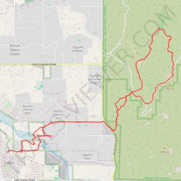
- Distance: 11.0 mi
- Elevation gain: 699 ft
- Maximum elevation: 3,179 ft
- Elevation loss: 656 ft
- Minimum elevation: 2,792 ft
- Moving time: 4 h 1 m
- Moving speed: 2.7 mph
- Maximum speed: 6.0 mph
- Total time: 4 h 52 m
- Global speed: 2.3 mph
Interactive trail map
Trail profile
- Distance: 11.0 mi
- Elevation gain: 699 ft
- Maximum elevation: 3,179 ft
- Elevation loss: 656 ft
- Minimum elevation: 2,792 ft
- Moving time: 4 h 1 m
- Moving speed: 2.7 mph
- Maximum speed: 6.0 mph
- Total time: 4 h 52 m
- Global speed: 2.3 mph
About this trail
Name: Hike the Cactus forest trail - with some detours trail, distance, elevation, map, profile, GPS track
End: Civano, Tucson, Pima County, Arizona, 85730, United States (32.15511 -110.76642)
Coordinates: 32.15479 -110.76642 32.18634 -110.71652
Topography: Tucson topographic map, elevation, terrain