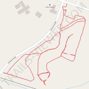
Jack Smith Creek Wetlands Trail
- Distance: 2.8 mi
- Elevation gain: 39 ft
- Maximum elevation: 10 ft
- Elevation loss: 39 ft
- Minimum elevation: -10 ft
- Moving time: 57 m 24 s
- Moving speed: 2.9 mph
- Maximum speed: 5.0 mph
- Total time: 58 m 8 s
- Global speed: 2.9 mph
Interactive trail map
Trail profile
- Distance: 2.8 mi
- Elevation gain: 39 ft
- Maximum elevation: 10 ft
- Elevation loss: 39 ft
- Minimum elevation: -10 ft
- Moving time: 57 m 24 s
- Moving speed: 2.9 mph
- Maximum speed: 5.0 mph
- Total time: 58 m 8 s
- Global speed: 2.9 mph
About this trail
Name: Jack Smith Creek Wetlands Trail trail, distance, elevation, map, profile, GPS track
Coordinates: 35.12194 -77.06741 35.12745 -77.06058
Topography: New Bern topographic map, elevation, terrain