Thank you for supporting this site ❤️
Make a donation
Make a donation
Gear up for your next adventure:
As an Amazon Associate, this site earns from qualifying purchases at no extra cost to you.
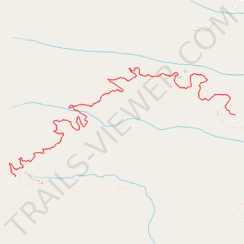
Lottie Queen Stamper Trail
- Distance: 4.0 mi
- Elevation gain: 1,260 ft
- Maximum elevation: 2,635 ft
- Elevation loss: 633 ft
- Minimum elevation: 1,929 ft
- Moving time: 1 h 33 m
- Moving speed: 2.5 mph
- Maximum speed: 6.5 mph
- Total time: 1 h 49 m
- Global speed: 2.2 mph
Interactive trail map
Thank you for supporting this site ❤️
Make a donation
Make a donation
Gear up for your next adventure:
As an Amazon Associate, this site earns from qualifying purchases at no extra cost to you.
Trail profile
- Distance: 4.0 mi
- Elevation gain: 1,260 ft
- Maximum elevation: 2,635 ft
- Elevation loss: 633 ft
- Minimum elevation: 1,929 ft
- Moving time: 1 h 33 m
- Moving speed: 2.5 mph
- Maximum speed: 6.5 mph
- Total time: 1 h 49 m
- Global speed: 2.2 mph
Thank you for supporting this site ❤️
Make a donation
Make a donation
Gear up for your next adventure:
As an Amazon Associate, this site earns from qualifying purchases at no extra cost to you.
About this trail
Name: Lottie Queen Stamper Trail trail, distance, elevation, map, profile, GPS track
Start: Upper Boulders Trail, Rutherford County, North Carolina, 28746, United States (35.49115 -82.19206)
Coordinates: 35.48520 -82.21899 35.49577 -82.19206
Topography: Rutherford County topographic map, elevation, terrain
Thank you for supporting this site ❤️
Make a donation
Make a donation
Gear up for your next adventure:
As an Amazon Associate, this site earns from qualifying purchases at no extra cost to you.