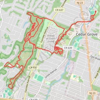
Hilltop Reservation
- Distance: 11.5 mi
- Elevation gain: 991 ft
- Maximum elevation: 659 ft
- Elevation loss: 994 ft
- Minimum elevation: 256 ft
- Moving time: 1 h 57 m
- Moving speed: 5.9 mph
- Maximum speed: 18.9 mph
- Total time: 1 h 59 m
- Global speed: 5.8 mph
Interactive trail map
Trail profile
- Distance: 11.5 mi
- Elevation gain: 991 ft
- Maximum elevation: 659 ft
- Elevation loss: 994 ft
- Minimum elevation: 256 ft
- Moving time: 1 h 57 m
- Moving speed: 5.9 mph
- Maximum speed: 18.9 mph
- Total time: 1 h 59 m
- Global speed: 5.8 mph
About this trail
Name: Hilltop Reservation trail, distance, elevation, map, profile, GPS track
Start: West Essex Trail, Cedar Grove, Essex County, New Jersey, 07009, United States (40.85788 -74.22570)
End: West Essex Trail, Cedar Grove, Essex County, New Jersey, 07009, United States (40.85792 -74.22572)
Coordinates: 40.83727 -74.25788 40.85792 -74.22567
Topography: Essex County topographic map, elevation, terrain
Other hiking, mountain biking, running and outdoor activity trails
Click on a trail to view its statistics, map and profile.
Cedar Grove Hilltop Reservation
United States > New Jersey > Essex County > Cedar Grove
Distance: 14.0 mi • Elevation gain: 1,312 ft • Maximum elevation: 692 ft
Cedar Grove
United States > New Jersey > Essex County > Newark
Afternoon Ride
Distance: 26.8 mi • Elevation gain: 1,309 ft • Maximum elevation: 535 ft
Cedar Grove
United States > New Jersey > Essex County > Montclair > Upper Montclair
Afternoon Ride
Distance: 14.9 mi • Elevation gain: 1,316 ft • Maximum elevation: 689 ft