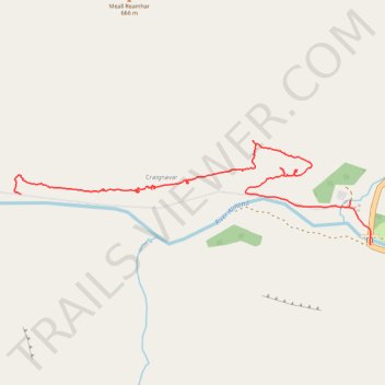
Exploring the building ruins of Craignavar township
- Distance: 2.0 mi
- Elevation gain: 348 ft
- Maximum elevation: 948 ft
- Elevation loss: 318 ft
- Minimum elevation: 712 ft
- Moving time: 1 h 2 m
- Moving speed: 2.0 mph
- Maximum speed: 5.2 mph
- Total time: 1 h 18 m
- Global speed: 1.6 mph
Interactive trail map
Trail profile
- Distance: 2.0 mi
- Elevation gain: 348 ft
- Maximum elevation: 948 ft
- Elevation loss: 318 ft
- Minimum elevation: 712 ft
- Moving time: 1 h 2 m
- Moving speed: 2.0 mph
- Maximum speed: 5.2 mph
- Total time: 1 h 18 m
- Global speed: 1.6 mph
About this trail
Name: Exploring the building ruins of Craignavar township trail, distance, elevation, map, profile, GPS track
Start: A822, Perth and Kinross, Scotland, PH7 3LW, United Kingdom (56.46219 -3.80683)
End: Craignavar, Perth and Kinross, Scotland, PH8 0EQ, United Kingdom (56.46430 -3.83306)
Coordinates: 56.46219 -3.83357 56.46651 -3.80679
Other hiking, mountain biking, running and outdoor activity trails
Click on a trail to view its statistics, map and profile.
Old Wade Road near Sma Glen
United Kingdom > Scotland > Perth and Kinross
Distance: 10.4 mi • Elevation gain: 1,024 ft • Maximum elevation: 1,473 ft