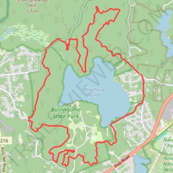
Burlingame State Park Loop
- Distance: 14.5 mi
- Elevation gain: 735 ft
- Maximum elevation: 197 ft
- Elevation loss: 735 ft
- Minimum elevation: 30 ft
- Moving time: 2 h 13 m
- Moving speed: 6.5 mph
- Maximum speed: 22.3 mph
- Total time: 2 h 21 m
- Global speed: 6.2 mph
Interactive trail map
Trail profile
- Distance: 14.5 mi
- Elevation gain: 735 ft
- Maximum elevation: 197 ft
- Elevation loss: 735 ft
- Minimum elevation: 30 ft
- Moving time: 2 h 13 m
- Moving speed: 6.5 mph
- Maximum speed: 22.3 mph
- Total time: 2 h 21 m
- Global speed: 6.2 mph
About this trail
Name: Burlingame State Park Loop trail, distance, elevation, map, profile, GPS track
Start: Sanctuary Road, Charlestown, South County, Rhode Island, 02813, United States (41.38012 -71.67697)
End: Sanctuary Road, Charlestown, South County, Rhode Island, 02813, United States (41.38010 -71.67698)
Coordinates: 41.36370 -71.71584 41.40680 -71.67438
Topography: South County topographic map, elevation, terrain
Other hiking, mountain biking, running and outdoor activity trails
Click on a trail to view its statistics, map and profile.
Vin Gormley Trail West Section
United States > Rhode Island > South County > Charlestown
Distance: 5.6 mi • Elevation gain: 213 ft • Maximum elevation: 98 ft