Thank you for supporting this site ❤️
Make a donation
Make a donation
Gear up for your next adventure:
As an Amazon Associate, this site earns from qualifying purchases at no extra cost to you.
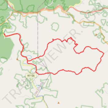
Redbird WMA Gravel Ride
- Distance: 23.2 mi
- Elevation gain: 2,415 ft
- Maximum elevation: 1,552 ft
- Elevation loss: 2,418 ft
- Minimum elevation: 843 ft
- Moving time: 3 h 1 m
- Moving speed: 7.7 mph
- Maximum speed: 25.2 mph
- Total time: 3 h 28 m
- Global speed: 6.7 mph
Interactive trail map
Thank you for supporting this site ❤️
Make a donation
Make a donation
Gear up for your next adventure:
As an Amazon Associate, this site earns from qualifying purchases at no extra cost to you.
Trail profile
- Distance: 23.2 mi
- Elevation gain: 2,415 ft
- Maximum elevation: 1,552 ft
- Elevation loss: 2,418 ft
- Minimum elevation: 843 ft
- Moving time: 3 h 1 m
- Moving speed: 7.7 mph
- Maximum speed: 25.2 mph
- Total time: 3 h 28 m
- Global speed: 6.7 mph
Thank you for supporting this site ❤️
Make a donation
Make a donation
Gear up for your next adventure:
As an Amazon Associate, this site earns from qualifying purchases at no extra cost to you.
About this trail
Name: Redbird WMA Gravel Ride trail, distance, elevation, map, profile, GPS track
Start: Frank Bowling Road, Peabody, Clay County, Kentucky, 40914, United States (37.14140 -83.59199)
End: Frank Bowling Road, Peabody, Clay County, Kentucky, 40914, United States (37.14133 -83.59204)
Coordinates: 37.10177 -83.59319 37.14258 -83.46839
Topography: Clay County topographic map, elevation, terrain
Thank you for supporting this site ❤️
Make a donation
Make a donation
Gear up for your next adventure:
As an Amazon Associate, this site earns from qualifying purchases at no extra cost to you.