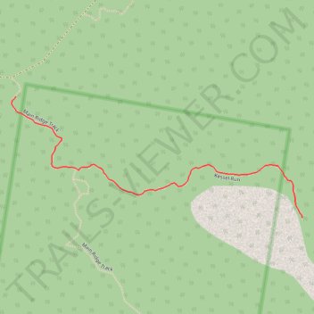
Kessel Run
- Distance: 0.6 mi
- Elevation gain: 118 ft
- Maximum elevation: 390 ft
- Elevation loss: 20 ft
- Minimum elevation: 285 ft
- Moving time: 17 m 50 s
- Moving speed: 2.0 mph
- Maximum speed: 3.6 mph
- Total time: 17 m 50 s
- Global speed: 2.0 mph
Interactive trail map
Trail profile
- Distance: 0.6 mi
- Elevation gain: 118 ft
- Maximum elevation: 390 ft
- Elevation loss: 20 ft
- Minimum elevation: 285 ft
- Moving time: 17 m 50 s
- Moving speed: 2.0 mph
- Maximum speed: 3.6 mph
- Total time: 17 m 50 s
- Global speed: 2.0 mph
About this trail
Name: Kessel Run trail, distance, elevation, map, profile, GPS track
Start: Main Ridge Track, White Rock, Ipswich City, Queensland, 4306, Australia (-27.68608 152.85399)
End: Kessel Run, White Rock, Ipswich City, Queensland, 4306, Australia (-27.68854 152.86055)
Coordinates: -27.68854 152.85390 -27.68608 152.86055
Other hiking, mountain biking, running and outdoor activity trails
Click on a trail to view its statistics, map and profile.
White Rock - Spring Mountain Conservation Estate
#MTB #WhiteRock #SpringMountain
Distance: 24.1 mi • Elevation gain: 2,956 ft • Maximum elevation: 1,070 ft
White Rock - Spring Mountain Conservation Estate
#MTB #Loop #WhiteRock #SpringMountain
Distance: 19.2 mi • Elevation gain: 2,894 ft • Maximum elevation: 692 ft