Thank you for supporting this site ❤️
Make a donation
Make a donation
Gear up for your next adventure:
As an Amazon Associate, this site earns from qualifying purchases at no extra cost to you.
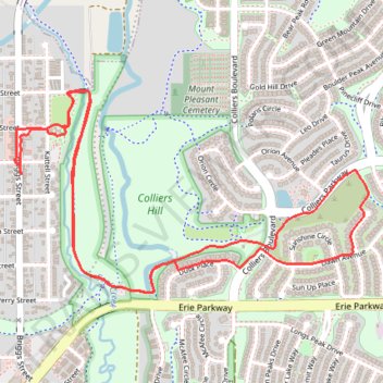
Colliers Hill and Coal Creek Open Space
- Distance: 3.7 mi
- Elevation gain: 135 ft
- Maximum elevation: 5,128 ft
- Elevation loss: 135 ft
- Minimum elevation: 5,016 ft
- Moving time: 1 h 13 m
- Moving speed: 3.1 mph
- Maximum speed: 3.7 mph
- Total time: 2 h 24 m
- Global speed: 1.6 mph
Interactive trail map
Thank you for supporting this site ❤️
Make a donation
Make a donation
Gear up for your next adventure:
As an Amazon Associate, this site earns from qualifying purchases at no extra cost to you.
Trail profile
- Distance: 3.7 mi
- Elevation gain: 135 ft
- Maximum elevation: 5,128 ft
- Elevation loss: 135 ft
- Minimum elevation: 5,016 ft
- Moving time: 1 h 13 m
- Moving speed: 3.1 mph
- Maximum speed: 3.7 mph
- Total time: 2 h 24 m
- Global speed: 1.6 mph
Thank you for supporting this site ❤️
Make a donation
Make a donation
Gear up for your next adventure:
As an Amazon Associate, this site earns from qualifying purchases at no extra cost to you.
About this trail
Name: Colliers Hill and Coal Creek Open Space trail, distance, elevation, map, profile, GPS track
Coordinates: 40.04419 -105.04763 40.05161 -105.03059
Topography: Weld County topographic map, elevation, terrain
Thank you for supporting this site ❤️
Make a donation
Make a donation
Gear up for your next adventure:
As an Amazon Associate, this site earns from qualifying purchases at no extra cost to you.
Other hiking, mountain biking, running and outdoor activity trails
Click on a trail to view its statistics, map and profile.
Loop Walk via Coal Creek Trail
United States > Colorado > Weld County > Erie
Distance: 3.1 mi • Elevation gain: 118 ft • Maximum elevation: 5,128 ft