Thank you for supporting this site ❤️
Make a donation
Make a donation
Gear up for your next adventure:
As an Amazon Associate, this site earns from qualifying purchases at no extra cost to you.
Wilmot - Falmouth
Interactive trail map
Thank you for supporting this site ❤️
Make a donation
Make a donation
Gear up for your next adventure:
As an Amazon Associate, this site earns from qualifying purchases at no extra cost to you.
Trail profile
- Distance: 56.2 mi
- Elevation gain: 2,041 ft
- Maximum elevation: 207 ft
- Elevation loss: 2,083 ft
- Minimum elevation: 10 ft
Thank you for supporting this site ❤️
Make a donation
Make a donation
Gear up for your next adventure:
As an Amazon Associate, this site earns from qualifying purchases at no extra cost to you.
About this trail
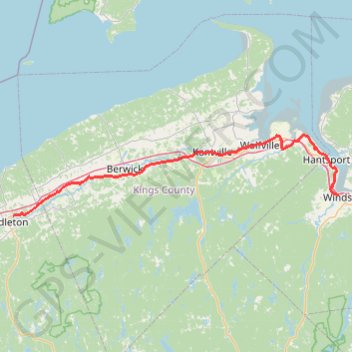
Name: Wilmot - Falmouth trail, distance, elevation, map, profile, GPS track
Coordinates: 44.95405 -65.04340 45.11000 -64.14801
Thank you for supporting this site ❤️
Make a donation
Make a donation
Gear up for your next adventure:
As an Amazon Associate, this site earns from qualifying purchases at no extra cost to you.
Other hiking, mountain biking, running and outdoor activity trails
Click on a trail to view its statistics, map and profile.
Gaspereau River Trail
Canada > Nova Scotia > Municipality of the County of Kings > White Rock
Distance: 5.2 mi • Elevation gain: 692 ft • Maximum elevation: 299 ft