Make a donation
Gear up for your next adventure:
As an Amazon Associate, this site earns from qualifying purchases at no extra cost to you.
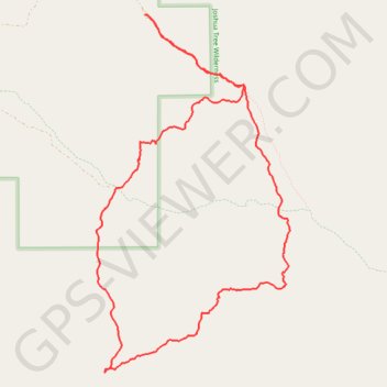
Covington Loop (Joshua Tree National Park)
Interactive trail map
Make a donation
Gear up for your next adventure:
As an Amazon Associate, this site earns from qualifying purchases at no extra cost to you.
Trail profile
- Distance: 8.4 mi
- Elevation gain: 994 ft
- Maximum elevation: 5,112 ft
- Elevation loss: 994 ft
- Minimum elevation: 4,475 ft
Make a donation
Gear up for your next adventure:
As an Amazon Associate, this site earns from qualifying purchases at no extra cost to you.
About this trail
Name: Covington Loop (Joshua Tree National Park) trail, distance, elevation, map, profile, GPS track
Start: Trail, Riverside County, California, United States (34.02774 -116.30229)
End: Trail, Riverside County, California, United States (34.02769 -116.30220)
Coordinates: 33.99037 -116.30836 34.02774 -116.28396
Topography: Riverside County topographic map, elevation, terrain
Make a donation
Gear up for your next adventure:
As an Amazon Associate, this site earns from qualifying purchases at no extra cost to you.
Other hiking, mountain biking, running and outdoor activity trails
Click on a trail to view its statistics, map and profile.