Import a GPX file

Iceline Trail - Takakkaw Falls

Yoho National Park. #Hiking #Loop #Yoho

  • Distance: 12.8 mi
  • Elevation gain: 2,890 ft
  • Maximum elevation: 7,303 ft
  • Elevation loss: 2,890 ft
  • Minimum elevation: 4,941 ft

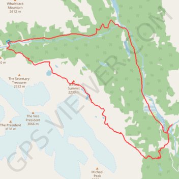
Interactive trail map

Trail profile

  • Distance: 12.8 mi
  • Elevation gain: 2,890 ft
  • Maximum elevation: 7,303 ft
  • Elevation loss: 2,890 ft
  • Minimum elevation: 4,941 ft

About this trail

Other hiking, mountain biking, running and outdoor activity trails

Click on a trail to view its statistics, map and profile.

Banff National Park - Lake Louise

Canada > Alberta > Improvement District No. 9

#Bike #Banff

Distance: 38.4 mi • Elevation gain: 1,972 ft • Maximum elevation: 6,686 ft

Gear up for your next adventure:

🧥Waterproof Jacket for Hiking - Breathable and rugged rain jacket for outdoor excursions
🚁Photography Drones - Capture stunning aerial views of landforms and topography
🧦Hiking Socks - Comfortable socks to prevent blisters on long hikes
🔊Portable Camp Speaker - Music and alerts at camp
🥾Women's Hiking Boots - Top-rated trail boots with ankle support and superior grip

As an Amazon Associate, this site earns from qualifying purchases at no extra cost to you.