Slovenia: Ratece - 3 borders - Ratece
- Distance: 8.0 mi
- Elevation gain: 2,392 ft
- Maximum elevation: 4,925 ft
- Elevation loss: 2,388 ft
- Minimum elevation: 2,835 ft
- Moving time: 3 h 5 m
- Moving speed: 2.6 mph
- Maximum speed: 15.6 mph
- Total time: 4 h 19 m
- Global speed: 1.8 mph
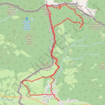
Interactive trail map
Trail profile
- Distance: 8.0 mi
- Elevation gain: 2,392 ft
- Maximum elevation: 4,925 ft
- Elevation loss: 2,388 ft
- Minimum elevation: 2,835 ft
- Moving time: 3 h 5 m
- Moving speed: 2.6 mph
- Maximum speed: 15.6 mph
- Total time: 4 h 19 m
- Global speed: 1.8 mph
About this trail
Name: Slovenia: Ratece - 3 borders - Ratece trail, distance, elevation, map, profile, GPS track
Start: Rateče, Kranjska Gora, 4283, Slovenia (46.49620 13.71925)
End: Rateče, Kranjska Gora, 4283, Slovenia (46.49624 13.71931)
Coordinates: 46.49620 13.70404 46.52308 13.72889
Other hiking, mountain biking, running and outdoor activity trails
Click on a trail to view its statistics, map and profile.
Monte Forno da Rateče SLO
Distance: 8.9 mi • Elevation gain: 2,467 ft • Maximum elevation: 4,925 ft