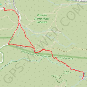
Sycamore Falls
- Distance: 3.7 mi
- Elevation gain: 686 ft
- Maximum elevation: 1,148 ft
- Elevation loss: 686 ft
- Minimum elevation: 801 ft
- Moving time: 1 h 35 m
- Moving speed: 2.3 mph
- Maximum speed: 3.6 mph
- Total time: 2 h 14 m
- Global speed: 1.6 mph
Interactive trail map
Trail profile
- Distance: 3.7 mi
- Elevation gain: 686 ft
- Maximum elevation: 1,148 ft
- Elevation loss: 686 ft
- Minimum elevation: 801 ft
- Moving time: 1 h 35 m
- Moving speed: 2.3 mph
- Maximum speed: 3.6 mph
- Total time: 2 h 14 m
- Global speed: 1.6 mph
About this trail
Name: Sycamore Falls trail, distance, elevation, map, profile, GPS track
Coordinates: 34.13975 -118.96545 34.15305 -118.94738
Topography: Thousand Oaks topographic map, elevation, terrain