Make a donation
Gear up for your next adventure:
As an Amazon Associate, this site earns from qualifying purchases at no extra cost to you.
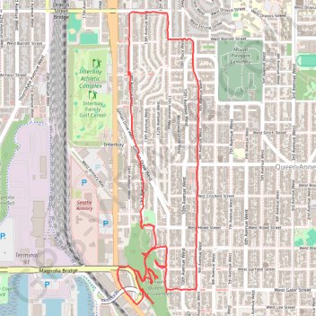
Queen Anne Greenbelt trails tracing
West Queen Anne Loop
- Distance: 4.3 mi
- Elevation gain: 653 ft
- Maximum elevation: 331 ft
- Elevation loss: 656 ft
- Minimum elevation: 16 ft
- Moving time: 1 h 36 s
- Moving speed: 4.2 mph
- Maximum speed: 10.4 mph
- Total time: 1 h 1 m
- Global speed: 4.1 mph
Interactive trail map
Make a donation
Gear up for your next adventure:
As an Amazon Associate, this site earns from qualifying purchases at no extra cost to you.
Trail profile
- Distance: 4.3 mi
- Elevation gain: 653 ft
- Maximum elevation: 331 ft
- Elevation loss: 656 ft
- Minimum elevation: 16 ft
- Moving time: 1 h 36 s
- Moving speed: 4.2 mph
- Maximum speed: 10.4 mph
- Total time: 1 h 1 m
- Global speed: 4.1 mph
Make a donation
Gear up for your next adventure:
As an Amazon Associate, this site earns from qualifying purchases at no extra cost to you.
About this trail
Name: Queen Anne Greenbelt trails tracing trail, distance, elevation, map, profile, GPS track
Coordinates: 47.63146 -122.37599 47.64838 -122.36903
Topography: Seattle topographic map, elevation, terrain
Make a donation
Gear up for your next adventure:
As an Amazon Associate, this site earns from qualifying purchases at no extra cost to you.
Other hiking, mountain biking, running and outdoor activity trails
Click on a trail to view its statistics, map and profile.
More biking around Seattle
United States > Washington > King County > Seattle
Distance: 13.2 mi • Elevation gain: 827 ft • Maximum elevation: 174 ft
Biking around Seattle
United States > Washington > King County > Seattle
Distance: 29.6 mi • Elevation gain: 1,335 ft • Maximum elevation: 180 ft