Thank you for supporting this site ❤️
Make a donation
Make a donation
Gear up for your next adventure:
As an Amazon Associate, this site earns from qualifying purchases at no extra cost to you.
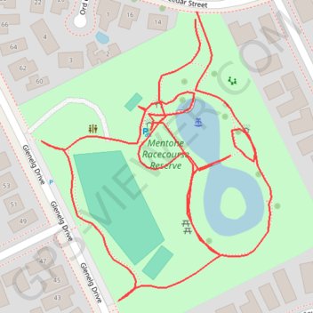
Mentone racecourse reserve
- Distance: 0.7 mi
- Elevation gain: 13 ft
- Maximum elevation: 79 ft
- Elevation loss: 13 ft
- Minimum elevation: 66 ft
- Moving time: 15 m 12 s
- Moving speed: 3.0 mph
- Maximum speed: 4.7 mph
- Total time: 15 m 12 s
- Global speed: 3.0 mph
Interactive trail map
Thank you for supporting this site ❤️
Make a donation
Make a donation
Gear up for your next adventure:
As an Amazon Associate, this site earns from qualifying purchases at no extra cost to you.
Trail profile
- Distance: 0.7 mi
- Elevation gain: 13 ft
- Maximum elevation: 79 ft
- Elevation loss: 13 ft
- Minimum elevation: 66 ft
- Moving time: 15 m 12 s
- Moving speed: 3.0 mph
- Maximum speed: 4.7 mph
- Total time: 15 m 12 s
- Global speed: 3.0 mph
Thank you for supporting this site ❤️
Make a donation
Make a donation
Gear up for your next adventure:
As an Amazon Associate, this site earns from qualifying purchases at no extra cost to you.
About this trail
Name: Mentone racecourse reserve trail, distance, elevation, map, profile, GPS track
End: Cedar Street, Mentone, Melbourne, City of Kingston, Victoria, 3194, Australia (-37.97758 145.07910)
Coordinates: -37.97948 145.07778 -37.97753 145.07975
Thank you for supporting this site ❤️
Make a donation
Make a donation
Gear up for your next adventure:
As an Amazon Associate, this site earns from qualifying purchases at no extra cost to you.
Other hiking, mountain biking, running and outdoor activity trails
Click on a trail to view its statistics, map and profile.