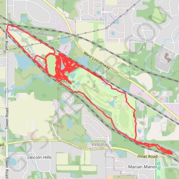
Creekside Trails
- Distance: 17.5 mi
- Elevation gain: 751 ft
- Maximum elevation: 722 ft
- Elevation loss: 751 ft
- Minimum elevation: 663 ft
Interactive trail map
Trail profile
- Distance: 17.5 mi
- Elevation gain: 751 ft
- Maximum elevation: 722 ft
- Elevation loss: 751 ft
- Minimum elevation: 663 ft
About this trail
Name: Creekside Trails trail, distance, elevation, map, profile, GPS track
Start: North 150 West, Valparaiso, Porter County, Indiana, 46383, United States (41.47988 -87.09528)
End: North 150 West, Valparaiso, Porter County, Indiana, 46383, United States (41.47982 -87.09527)
Coordinates: 41.46880 -87.11424 41.48792 -87.08170
Topography: Valparaiso topographic map, elevation, terrain
Other hiking, mountain biking, running and outdoor activity trails
Click on a trail to view its statistics, map and profile.
Creekside Trails
United States > Indiana > Porter County > Valparaiso
Mountain Biking
Distance: 12.9 mi • Elevation gain: 436 ft • Maximum elevation: 817 ft