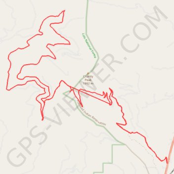
Charity peak area arlee to above frenchtown area
- Distance: 27.2 mi
- Elevation gain: 4,127 ft
- Maximum elevation: 6,198 ft
- Elevation loss: 4,127 ft
- Minimum elevation: 3,980 ft
Interactive trail map
Trail profile
- Distance: 27.2 mi
- Elevation gain: 4,127 ft
- Maximum elevation: 6,198 ft
- Elevation loss: 4,127 ft
- Minimum elevation: 3,980 ft
About this trail
Name: Charity peak area arlee to above frenchtown area trail, distance, elevation, map, profile, GPS track
Start: Missoula County, Montana, United States (47.04492 -114.08192)
End: Missoula County, Montana, United States (47.04459 -114.08200)
Coordinates: 47.04412 -114.17426 47.10409 -114.08167
Topography: Missoula County topographic map, elevation, terrain
Other hiking, mountain biking, running and outdoor activity trails
Click on a trail to view its statistics, map and profile.
Bike ride on the slopes of Charity Peak
United States > Montana > Missoula County > Schley
Morning Ride
Distance: 10.2 mi • Elevation gain: 1,854 ft • Maximum elevation: 5,105 ft
Morning Mountain Bike Ride
United States > Montana > Missoula County > Schley
Distance: 13.0 mi • Elevation gain: 1,257 ft • Maximum elevation: 4,058 ft