Make a donation
Gear up for your next adventure:
As an Amazon Associate, this site earns from qualifying purchases at no extra cost to you.
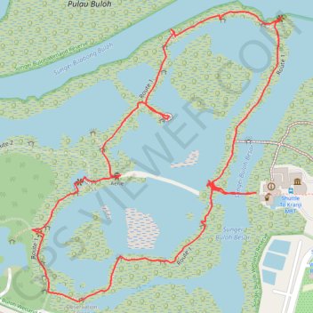
Sungei Buloh Wetland Route
Enjoy the tranquility and serenity of the mangrove habitat is through Route 1. This route goes around the two main ponds and gives a good introduction to the Reserve and the birds of Sungei Buloh, especially during the migratory season from September to March
From https://www.aussiebushwalking.com/overseas/sungei-buloh-wetland-route-1
- Distance: 1.6 mi
- Elevation gain: 52 ft
- Maximum elevation: 30 ft
- Elevation loss: 52 ft
- Minimum elevation: 0 ft
- Moving time: 48 m 36 s
- Moving speed: 2.0 mph
- Maximum speed: 4.2 mph
- Total time: 1 h 17 m
- Global speed: 1.3 mph
Interactive trail map
Make a donation
Gear up for your next adventure:
As an Amazon Associate, this site earns from qualifying purchases at no extra cost to you.
Trail profile
- Distance: 1.6 mi
- Elevation gain: 52 ft
- Maximum elevation: 30 ft
- Elevation loss: 52 ft
- Minimum elevation: 0 ft
- Moving time: 48 m 36 s
- Moving speed: 2.0 mph
- Maximum speed: 4.2 mph
- Total time: 1 h 17 m
- Global speed: 1.3 mph
Make a donation
Gear up for your next adventure:
As an Amazon Associate, this site earns from qualifying purchases at no extra cost to you.
About this trail
Name: Sungei Buloh Wetland Route trail, distance, elevation, map, profile, GPS track
Coordinates: 1.44398 103.72410 1.44970 103.72903
Make a donation
Gear up for your next adventure:
As an Amazon Associate, this site earns from qualifying purchases at no extra cost to you.
Other hiking, mountain biking, running and outdoor activity trails
Click on a trail to view its statistics, map and profile.
Directions from Duck Tour Ramp to Marina Boulevard, Singapore
Distance: 65.5 mi • Elevation gain: 2,664 ft • Maximum elevation: 167 ft