Thank you for supporting this site ❤️
Make a donation
Make a donation
Gear up for your next adventure:
As an Amazon Associate, this site earns from qualifying purchases at no extra cost to you.
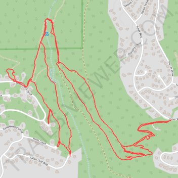
Trails near Second Creek
- Distance: 4.4 mi
- Elevation gain: 958 ft
- Maximum elevation: 7,365 ft
- Elevation loss: 955 ft
- Minimum elevation: 6,919 ft
- Moving time: 1 h 40 m
- Moving speed: 2.6 mph
- Maximum speed: 7.9 mph
- Total time: 1 h 45 m
- Global speed: 2.5 mph
Interactive trail map
Thank you for supporting this site ❤️
Make a donation
Make a donation
Gear up for your next adventure:
As an Amazon Associate, this site earns from qualifying purchases at no extra cost to you.
Trail profile
- Distance: 4.4 mi
- Elevation gain: 958 ft
- Maximum elevation: 7,365 ft
- Elevation loss: 955 ft
- Minimum elevation: 6,919 ft
- Moving time: 1 h 40 m
- Moving speed: 2.6 mph
- Maximum speed: 7.9 mph
- Total time: 1 h 45 m
- Global speed: 2.5 mph
Thank you for supporting this site ❤️
Make a donation
Make a donation
Gear up for your next adventure:
As an Amazon Associate, this site earns from qualifying purchases at no extra cost to you.
About this trail
Name: Trails near Second Creek trail, distance, elevation, map, profile, GPS track
Coordinates: 39.25969 -119.98134 39.26773 -119.96925
Topography: Washoe County topographic map, elevation, terrain
Thank you for supporting this site ❤️
Make a donation
Make a donation
Gear up for your next adventure:
As an Amazon Associate, this site earns from qualifying purchases at no extra cost to you.