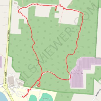
Denison Preserve Trail
- Distance: 2.0 mi
- Elevation gain: 269 ft
- Maximum elevation: 1,106 ft
- Elevation loss: 272 ft
- Minimum elevation: 965 ft
- Moving time: 58 m 42 s
- Moving speed: 2.1 mph
- Maximum speed: 7.0 mph
- Total time: 1 h 7 m
- Global speed: 1.8 mph
Interactive trail map
Trail profile
- Distance: 2.0 mi
- Elevation gain: 269 ft
- Maximum elevation: 1,106 ft
- Elevation loss: 272 ft
- Minimum elevation: 965 ft
- Moving time: 58 m 42 s
- Moving speed: 2.1 mph
- Maximum speed: 7.0 mph
- Total time: 1 h 7 m
- Global speed: 1.8 mph
About this trail
Name: Denison Preserve Trail trail, distance, elevation, map, profile, GPS track
Coordinates: 40.07666 -82.52007 40.08432 -82.51310
Topography: Licking County topographic map, elevation, terrain