Make a donation
Gear up for your next adventure:
As an Amazon Associate, this site earns from qualifying purchases at no extra cost to you.
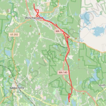
Rail trails and other trails Winchendon/Gardner
- Distance: 19.1 mi
- Elevation gain: 978 ft
- Maximum elevation: 1,129 ft
- Elevation loss: 981 ft
- Minimum elevation: 955 ft
- Moving time: 1 h 45 m
- Moving speed: 10.9 mph
- Maximum speed: 19.7 mph
- Total time: 1 h 47 m
- Global speed: 10.7 mph
Interactive trail map
Make a donation
Gear up for your next adventure:
As an Amazon Associate, this site earns from qualifying purchases at no extra cost to you.
Trail profile
- Distance: 19.1 mi
- Elevation gain: 978 ft
- Maximum elevation: 1,129 ft
- Elevation loss: 981 ft
- Minimum elevation: 955 ft
- Moving time: 1 h 45 m
- Moving speed: 10.9 mph
- Maximum speed: 19.7 mph
- Total time: 1 h 47 m
- Global speed: 10.7 mph
Make a donation
Gear up for your next adventure:
As an Amazon Associate, this site earns from qualifying purchases at no extra cost to you.
About this trail
Name: Rail trails and other trails Winchendon/Gardner trail, distance, elevation, map, profile, GPS track
Start: Park Street, Gardner, Worcester County, Massachusetts, 01440, United States (42.59267 -71.99879)
End: Park Street, Gardner, Worcester County, Massachusetts, 01440, United States (42.59245 -71.99883)
Coordinates: 42.59219 -72.05040 42.69612 -71.99525
Topography: Worcester County topographic map, elevation, terrain
Make a donation
Gear up for your next adventure:
As an Amazon Associate, this site earns from qualifying purchases at no extra cost to you.