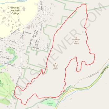
Northfield State Forest (NSF) - Richardson Loop Trail (yellow)
- Distance: 5.0 mi
- Elevation gain: 666 ft
- Maximum elevation: 958 ft
- Elevation loss: 659 ft
- Minimum elevation: 413 ft
- Moving time: 1 h 10 m
- Moving speed: 4.2 mph
- Maximum speed: 7.9 mph
- Total time: 1 h 25 m
- Global speed: 3.5 mph
Interactive trail map
Trail profile
- Distance: 5.0 mi
- Elevation gain: 666 ft
- Maximum elevation: 958 ft
- Elevation loss: 659 ft
- Minimum elevation: 413 ft
- Moving time: 1 h 10 m
- Moving speed: 4.2 mph
- Maximum speed: 7.9 mph
- Total time: 1 h 25 m
- Global speed: 3.5 mph
About this trail
Name: Northfield State Forest (NSF) - Richardson Loop Trail (yellow) trail, distance, elevation, map, profile, GPS track
Coordinates: 42.69744 -72.44245 42.71720 -72.42097
Topography: Franklin County topographic map, elevation, terrain
Other hiking, mountain biking, running and outdoor activity trails
Click on a trail to view its statistics, map and profile.
Northfield Trail Running
United States > Massachusetts > Franklin County > Northfield > East Northfield
Northfield Mountain Yellow
Distance: 4.9 mi • Elevation gain: 666 ft • Maximum elevation: 955 ft