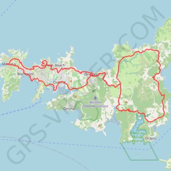
Waiheke Island Bike Loop
Loop bike around Waiheke Island from Matiatia Bay via Oneroa, Palm Beach, Onetangi, Man o'War Bay, Te Matuku Bay, Ostend, Surfdale and Blackpool. #Bike #Loop #Waiheke #Island #Nature #Sea #Pacific #Ocean #Forest #Countryside
- Distance: 38.4 mi
- Elevation gain: 5,564 ft
- Maximum elevation: 486 ft
- Elevation loss: 5,568 ft
- Minimum elevation: 0 ft
- Moving time: 5 h 50 m
- Moving speed: 6.6 mph
- Maximum speed: 39.1 mph
- Total time: 9 h 51 m
- Global speed: 3.9 mph
Interactive trail map
Trail profile
- Distance: 38.4 mi
- Elevation gain: 5,564 ft
- Maximum elevation: 486 ft
- Elevation loss: 5,568 ft
- Minimum elevation: 0 ft
- Moving time: 5 h 50 m
- Moving speed: 6.6 mph
- Maximum speed: 39.1 mph
- Total time: 9 h 51 m
- Global speed: 3.9 mph
About this trail
Name: Waiheke Island Bike Loop trail, distance, elevation, map, profile, GPS track
Start: Mātiatia Wharf, Ocean View Road, Matiatia, Waiheke, Auckland, New Zealand (-36.78043 174.99254)
Coordinates: -36.82971 174.99235 -36.76811 175.15956