Thank you for supporting this site ❤️
Make a donation
Make a donation
Gear up for your next adventure:
As an Amazon Associate, this site earns from qualifying purchases at no extra cost to you.
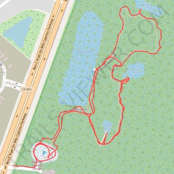
Trace of the board walk at Six Mile Cypress Slough Preserve
- Distance: 2.2 mi
- Elevation gain: 16 ft
- Maximum elevation: 26 ft
- Elevation loss: 16 ft
- Minimum elevation: 16 ft
Interactive trail map
Thank you for supporting this site ❤️
Make a donation
Make a donation
Gear up for your next adventure:
As an Amazon Associate, this site earns from qualifying purchases at no extra cost to you.
Trail profile
- Distance: 2.2 mi
- Elevation gain: 16 ft
- Maximum elevation: 26 ft
- Elevation loss: 16 ft
- Minimum elevation: 16 ft
Thank you for supporting this site ❤️
Make a donation
Make a donation
Gear up for your next adventure:
As an Amazon Associate, this site earns from qualifying purchases at no extra cost to you.
About this trail
Name: Trace of the board walk at Six Mile Cypress Slough Preserve trail, distance, elevation, map, profile, GPS track
End: Lee County, Florida, 33912, United States (26.57066 -81.82745)
Coordinates: 26.57060 -81.82745 26.57598 -81.82189
Topography: Lee County topographic map, elevation, terrain
Thank you for supporting this site ❤️
Make a donation
Make a donation
Gear up for your next adventure:
As an Amazon Associate, this site earns from qualifying purchases at no extra cost to you.