Make a donation
Gear up for your next adventure:
As an Amazon Associate, this site earns from qualifying purchases at no extra cost to you.
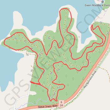
Ferny Forest Loop - Ewan Maddock Dam
#Hiking #Loop #Ferny #EwanMaddock
- Distance: 5.6 mi
- Elevation gain: 354 ft
- Maximum elevation: 167 ft
- Elevation loss: 354 ft
- Minimum elevation: 69 ft
Interactive trail map
Make a donation
Gear up for your next adventure:
As an Amazon Associate, this site earns from qualifying purchases at no extra cost to you.
Trail profile
- Distance: 5.6 mi
- Elevation gain: 354 ft
- Maximum elevation: 167 ft
- Elevation loss: 354 ft
- Minimum elevation: 69 ft
Make a donation
Gear up for your next adventure:
As an Amazon Associate, this site earns from qualifying purchases at no extra cost to you.
About this trail
Name: Ferny Forest Loop - Ewan Maddock Dam trail, distance, elevation, map, profile, GPS track
Start: T8, Landsborough, Sunshine Coast Regional, Queensland, 4553, Australia (-26.79140 152.99851)
End: T8, Landsborough, Sunshine Coast Regional, Queensland, 4553, Australia (-26.79128 152.99851)
Coordinates: -26.79419 152.99416 -26.78059 153.01085
Make a donation
Gear up for your next adventure:
As an Amazon Associate, this site earns from qualifying purchases at no extra cost to you.
Other hiking, mountain biking, running and outdoor activity trails
Click on a trail to view its statistics, map and profile.
Currimundi - Ewen Maddock Dam - Beerburrum
Australia > Queensland > Sunshine Coast Regional
Distance: 34.1 mi • Elevation gain: 1,460 ft • Maximum elevation: 154 ft
Ewen Maddock Dam Main Track
Australia > Queensland > Sunshine Coast Regional
Distance: 5.0 mi • Elevation gain: 338 ft • Maximum elevation: 151 ft
Make a donation
Gear up for your next adventure:
As an Amazon Associate, this site earns from qualifying purchases at no extra cost to you.