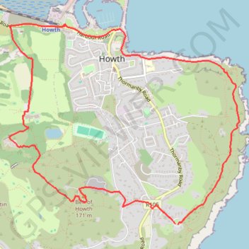
Thank you for supporting this site ❤️
Make a donation
Make a donation
Gear up for your next adventure:
As an Amazon Associate, this site earns from qualifying purchases at no extra cost to you.
Howth - Dublin
Interactive trail map
Thank you for supporting this site ❤️
Make a donation
Make a donation
Gear up for your next adventure:
As an Amazon Associate, this site earns from qualifying purchases at no extra cost to you.
Trail profile
- Distance: 5.4 mi
- Elevation gain: 804 ft
- Maximum elevation: 525 ft
- Elevation loss: 804 ft
- Minimum elevation: -3 ft
Thank you for supporting this site ❤️
Make a donation
Make a donation
Gear up for your next adventure:
As an Amazon Associate, this site earns from qualifying purchases at no extra cost to you.
About this trail
Name: Howth - Dublin trail, distance, elevation, map, profile, GPS track
Coordinates: 53.37078 -6.08070 53.38895 -6.04571
Thank you for supporting this site ❤️
Make a donation
Make a donation
Gear up for your next adventure:
As an Amazon Associate, this site earns from qualifying purchases at no extra cost to you.
Other hiking, mountain biking, running and outdoor activity trails
Click on a trail to view its statistics, map and profile.
Howth Bog of Frogs Loop
Ireland > County Dublin > Howth
Distance: 7.4 mi • Elevation gain: 1,404 ft • Maximum elevation: 407 ft