Thank you for supporting this site ❤️
Make a donation
Make a donation
Gear up for your next adventure:
As an Amazon Associate, this site earns from qualifying purchases at no extra cost to you.
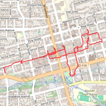
Tracked with OSMTracker for Android™
murals
- Distance: 2.9 mi
- Elevation gain: 72 ft
- Maximum elevation: 5,390 ft
- Elevation loss: 59 ft
- Minimum elevation: 5,328 ft
- Moving time: 1 h 22 m
- Moving speed: 2.1 mph
- Maximum speed: 15.2 mph
- Total time: 2 h 23 m
- Global speed: 1.2 mph
Interactive trail map
Thank you for supporting this site ❤️
Make a donation
Make a donation
Gear up for your next adventure:
As an Amazon Associate, this site earns from qualifying purchases at no extra cost to you.
Trail profile
- Distance: 2.9 mi
- Elevation gain: 72 ft
- Maximum elevation: 5,390 ft
- Elevation loss: 59 ft
- Minimum elevation: 5,328 ft
- Moving time: 1 h 22 m
- Moving speed: 2.1 mph
- Maximum speed: 15.2 mph
- Total time: 2 h 23 m
- Global speed: 1.2 mph
Thank you for supporting this site ❤️
Make a donation
Make a donation
Gear up for your next adventure:
As an Amazon Associate, this site earns from qualifying purchases at no extra cost to you.
About this trail
Name: Tracked with OSMTracker for Android™ trail, distance, elevation, map, profile, GPS track
End: 600, Pearl Street, Boulder, Boulder County, Colorado, 80302, United States (40.01604 -105.28769)
Coordinates: 40.01520 -105.28775 40.02047 -105.27329
Topography: Boulder topographic map, elevation, terrain
Thank you for supporting this site ❤️
Make a donation
Make a donation
Gear up for your next adventure:
As an Amazon Associate, this site earns from qualifying purchases at no extra cost to you.